 |
 |
 |
 |
|||||||||||||||
 |
||||||||||||||
 |
||||||||||||||
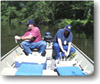
| Surface run-off from Stennis Space Center drains into Devil's Swamp and into the Pearl River. These bodies (especially the Pearl River, which drains directly into the Gulf of Mexico) are closely monitored to assure that Stennis Space Center is fully protective of the environment.
Samples are taken on a regular basis and returned to the Environmental Lab for analysis. On site field data is also recorded. |
||||||||||||||
 |
||||||||||||||
Surface waterways around SSC are suitable for recreation and support fish and wildlife. The Mississippi and Pearl Rivers are the main waterways through the region, both of which are navigable and flow into the Gulf of Mexico. The East Pearl River flows along the southwest boundary of the Fee Area and the Jourdan River flows though the eastern portion of the Buffer Zone. Mikes River, Turtleskin Creek, and the Lion and Wolf branches of Catahoula Creek drain the Fee Area and are connected to the Lion and Wolf branches of Catahoula Creek drain the Fee Area and are connected to the East Pearl and Jourdan Rivers. The Pearl and Jourdan Rivers are suitable for recreation. Mike's River and the Lion and Wolf branched support fish and wildlife. The southeastern portion of SSC drains into the main access canal. The canal is connected to the East Pearl River though a lock system. Water from the Access Canal is used for emergency fire suppression and rocket testing cooling. |
||||||||||||||
 |
||||||||||||||
|
|
||||||||||||||